Foreword I
I have barely posted here for months, and the biggest reason for that has been my laser focus on something that no one but my husband has known about since early December of last year. For those few souls who have missed my words, here are more than 5000 of them crammed into one post for you to enjoy! (Or skim, or skip …)
Foreword II
How can I possibly explain this folly?
There was nothing – nothing – I liked less than walking up a long, steep hill. I hated to breathe hard, I hated to sweat, and I hated the feeling of being physically and mentally uncomfortable. I do love to hike, though, and I do love to stand on top of mountains, so I have suffered through these grueling, awful ascents for years. I walked slowly and breathed hard, but my modus operandi was to just keep moving. I was almost always slower than other people going uphill, but fortunately, hiking involves plenty of flat, rolling, and downhill sections, where I walk quite briskly, so it has been hard for others (and even me, to some extent) to tell that I completely sucked at walking uphill. I have hiked very, very high (to almost 18,000’) and I have hiked for a very long time (almost 3 straight weeks), but in the midst of those achievements and others, I have been 100% miserable and cranky with myself on every long, difficult climb.
December 4, 2018
So, what do I decide to do when I read an article about an event that involves walking up 2310 very steep vertical feet in the middle of August in high-altitude Utah? But wait, let me expand. I was not just going to walk up that steep hill and then mosey down a few hours later and have a beer. I was going to try to walk up Snowbasin Mountain thirteen (that’s 13) times over a 36-hour period for a grand total of 29,029 vertical feet. In the debut of this event in Utah last summer, only 35% of the participants went all the way. And they probably never truly loathed or were bad at walking uphill. Oh, and I’m going to pay someone thousands of dollars to make this happen.
To put this in perspective, event founder Jesse Itzler told us that elevating one’s heart rate and shredding one’s leg, core, and even arm muscles for 36 hours is like running nine average-speed marathons back-to-back, or doing 2.5 Ironman triathlons in a row. I’ve never done more than a 10K race. When you reach a normal cruising altitude in a jet, look down; that’s the height we are going to have to climb. On my most ambitious hiking days, I’d maybe go up 4000 feet. When I decide to finally test my limits, could I not be a little more reasonable?
I read the article at 7:30 am in Outside Online and almost impulsively sign up immediately. I send the link to my husband, J, and write “I want to do this!” I am so pumped. The year of the event will contain a big birthday for me, and I have been feeling a need to show myself I can still cut it, to go BIG, to escape the limiting thoughts and negative self-talk that have consumed me in the last few years. I click the Chat button and bombard Matt, VP of Sales, with questions. I head out for the day, brain afire, and return afterward and call Matt to talk more. I crunch numbers, I read reviews and testimonials online, and I get more fired up.
This opportunity to face many of my personal fears and weaknesses should be my 60th birthday present to myself, I decide. And the significance of the number 29029 cannot be overstated. This is the height of Mount Everest – my dream, my fantasy, my obsession for years and years. (Surely you’ve noticed my header photo for the last five years!) I’d like to believe that I could still climb Mount Everest, and I still dream of it regularly, but at my age, with no alpine climbing experience, and no $50,000+ to spare, I have accepted realistically that this is not going to happen for me. The 29029 event lines up so beautifully with the biggest dream I’ve ever had for myself, and it now seems like a bargain basement way to test my physical and mental limits.
December 5, 2018
I’m still high, but I have to face the fact that I probably do not have the ability to do any of this. I have another conversation with Matt. I read more, calculate more, debate more, and then I decide to see what I can even do as a baseline. I try walking the length of one summit hike on the highest ramp on my treadmill (not even close to the real thing), after a full tennis match to simulate tiredness, and then I do all the calculations to account for altitude and slope and the necessary ride back down after each ascent. I figure I’ll need at least two hours per summit, and there are thirteen summits to do. I have 36 hours total, and I will need 26 hours just to walk it all with no major breakdowns. That leaves me with ten hours to sleep, rest, eat, pee, and deal with any screaming muscles, joints, bones, and mental collapses. I can do that!
December 6, 2018
But have I discounted the pain of a real climb? I get on the Stairmaster at my gym the next day and make it about 8.5 minutes before I feel my steps are shaky. I am breathing hard and sweating; I usually stop before this happens (typed sheepishly, but true). I get off and decide this event is likely not for me. Thousands of bucks to do something for 36 hours that I just hated passionately for 8.5 minutes?
Later that afternoon, I realize I can’t give up the whole event just because I am unlikely to finish it or even do well at it. I just wanna be with these people! Colin O’Brady (first solo trans-Antarctica trekker and all-around endurance badass AND exemplary human) has done this twice! Olympic sprinters have participated. NFL players. Duke’s Coach K has had Jesse Itzler speak to his teams. It’s a hell of a lot of money to “just be with these people,” but … can I perhaps lower my expectations? Can I just train as hard as I possibly can and go and do whatever I can? They say it’s about “you versus you,” not a race, and I can buy into that mentality.
December 7, 2018
I tell Matt I am wavering. He sends some testimonials by others – a woman who does the whole thing in Vermont, a different woman who doesn’t make it and still extols the event, a guy who trains his butt off (literally; he loses 45 pounds) and gets it done. Another guy who goes hoping to summit once and makes it up five times (and is thrilled). I am reinvigorated. Maybe I should go to just be inspired by all these people and do whatever I can.
Or maybe I really can train enough to do it all?! F— it – I’m in! I don’t even wait for Matt to respond to my last email; I close my eyes, take a deep breath, and push the Buy button. Holy crap; what have I done? I justify. I can get some money back if I withdraw by late February. Won’t I know by then if this training business simply can’t get me ready after years of half-hearted cardio?
April, 2019
Flash forward to the start of our training program. I’ve spent the last four months training for the training program. Sad but true. I’ve gone from ten minutes on the Stairmaster to thirty. I am regularly running hill repeats and trudging uphill on an inclined treadmill. I can now run about three miles at a conversational pace and have found my latest high-altitude hike in Bhutan quite manageable. Easy, in fact, which makes me feel much more confident. And now the real work begins.
April-August, 2019
I’ve become a running fool. My running shoes go with me everywhere. Georgia, Pennsylvania, Northern California, Boston, Arkansas. I run four, then six, then eight miles at a time. I run five miles to my health club, do six hours of stepmill and treadmill workouts indoors, then run the five miles back home. I experiment with on-the-go hydration and nutrition, seeing what I digest well and what upsets my stomach.
This is all well and good, but will it get me up a steep, steep mountain thirteen times in a row? All day and through the night? At 9000 feet of elevation? At up to a 47% incline? Nothing I can do will truly prepare me for this event, I feel sure.
Our trainer Brent says, “the bigger the base, the higher the peak,” and this becomes my mantra. The more miles I put on my legs and feet now, the more ready they will be to go high and far in late August. At the same time, he urges us to “train where you are.” There is an online group for participants, and many are wearing weighted vests and spending hours at a time on a stepmill or a real mountain. We don’t even have hills in Houston. Some are organizing outings to the event venue. Others are doubling the mileages and times. But I plug away at my own pace, trusting in Brent’s reasonable philosophy. At my age, I also have to think about preventing injury; what good will I be at the event if I go overboard now?
Mid-summer brings certain facts into focus. One moment of truth is a grim reality check: after a one-hour run on June 4, in stifling heat and humidity, I try to do the required hill repeats and then my hip mobility exercises, and simply cannot finish them. The incline at my small Houston hill is 40-60%, about the level of the toughest slopes at Snowbasin, and I think I will die if I have to keep going … and this is after only 1.5 hours of exercise. How am I going to repeat that infinitely longer hill for 36 hours? Really, I am a fool to think I can rack up all thirteen summits in just a few months from now. Perhaps I can crunch out five ascents … maybe, maybe go up seven times?
Then again, after I get in the car and come home, I think about how OK I feel after fifteen minutes, and that I might actually be able to go out and start again. Time will tell. But I will need to push myself a lot harder, and that’ll be tough given that I am feeling wasted, hungry, and tired all the time.
A month out from the event, I experiment with the advanced slanted treadmill at my gym. I set the machine at a 20% incline right from the start and walk up 2310 feet in 67 minutes at a fairly comfortable pace and heart rate. If only the event could replicate this! At this pace, I’d have time to ride back down and even take a short rest before turning back up the mountain. Of course, 20% is only the average incline of the real mountain, and the real mountain also has gravel, rocks, boulders, straw, and uneven earth. It has blazing hot days and 40-degree nights. It has sections at double these slopes … okay, so maybe I can still hope to finish in less than twice this time. A two-hour ascent will still let me take a few short breaks, but there goes any chance to actually sleep at night.
By the end of July and into early August, we are at the peak of our training. We have three straight weekends of multi-workout days – days when we run or hike or cross-train for eight, ten, or twelve hours straight. This has become my weekend life, but I refuse to fall into the endurance training rabbit hole. One day I get up at 5 am so I can get the training done and still throw a dinner party for visiting relatives that night. We stick to our plans for dinner with friends at other times, and I attack my food like I’ve just burned it and a few more days’ worth of calories off beforehand (I have).
I feel strong! As I go into the taper weeks, J and I head west to hike in Idaho and Utah for almost a week before my event. I take it easy on my hikes, and I watch my footsteps like I never have before. No turned ankles allowed right now. No sore knees or hips, please. At the end of the week, J drops me at the site. I am a nervous wreck. Ready physically, but how will I ever know if I have the mental fortitude to climb up, up, and up, over and over again, all day and all night for the next day and a half.
I listen to the pre-event speeches, tucking tidbits of information and advice away for tomorrow, settle into my tent for a night of tossing and turning, and set my alarm for 4 am. Tomorrow at 5:45, we will strap on our headlamps and start up the mountain.

***
We start at 6 am, in the dark, with headlamps illuminating only the rocky patches of ground beneath us and the already-dusty trail shoes of the hiker in front of us. Perhaps this is good; we have seen the first one-tenth of the hill from the base, and it is beyond daunting. At about a 47-degree slope, the pitch makes our heartrates jump and our calves scream from minute one. When we see the first sign, meant to be helpful but certainly not, it says we have climbed a mere 500 feet. Most of us stop for a breather, a drink and a few hundred calories about 300 vertical feet later, at Aid Station 1. Taking care of our hydration and nutrition will be critical in the next day and a half as we burn thousands of calories and sweat out our water and salt stores with every ascent.

In spite of my careful plan to hike only at my own comfortable pace, I reach the first summit quite a bit faster than I had calculated. As I take the 15-minute ride back down to the base, I feel good. Strong and optimistic. I’ve just saved myself a good 45 minutes over my estimates, I calculate – time later for a nap or a real meal or a mental or physical breakdown. “Stay ahead of the clock,” we were advised. No time to gloat now; I need to keep moving and not even think about those extra minutes I’ve stockpiled.
Getting off the gondola and heading back to the starting chute is an eye-opening reminder that this is not going to be a walk in the woods. Our group of 220 hikers has spread out, and as I approach the board where we brand each ascent into the wood, I don’t see anyone I know, so I trudge to the starting line alone and begin to labor uphill on my own. It is light enough now to see, and I soon realize that the first 750 feet of this hill is perhaps the longest and most difficult stretch of all. It’s a sobering discovery; every time I start over, I’m going to have to find the will to walk through serious discomfort and exhaustion.

But Jesse and other speakers have addressed just this. “Be where your feet are,” we were told. I need to think about nothing but the next step – not the section above this, not the last hike where a steep jumble of boulders almost caused me to tip over backward, certainly not the fact that I have finished only one hike out of thirteen. One-two-one-two, click with the right pole, clack with the left. Breathe calmly; don’t outpace your breath. For me, a key will be to not stop between stations. Others are walking faster than I am, huffing and puffing, churning uphill past me. Minutes later, I am passing them as they bend over their poles, catching a breath, stretching a calf muscle. Already I feel a Zen-like calm, an autopilot rhythm that is propelling me up the mountain.
Last night a few speakers suggested we not put in earphones, letting our own thoughts and the nature around us fill our heads. This was heresy, I thought at the time; my music and my GPS watch have been my security blankets for months of training. Now I realize I have forgotten to push the Workout button on my watch for the first lap and the early part of my second. But by now I know my breath and heart rate patterns; I don’t think I’m exceeding a safe zone, and somehow the lack of music really IS keeping me focused on my feet.
And so go laps 2, 3, and 4, which I decide to do without any real breaks even though my pre-event plan was to stop for lunch after three climbs. Our rewards come in two ways: ascent count and a summit count. We are going for all Seven Summits, and it will take these first four ascents to get me to the equivalent of Mount Kosciuszko (Australia’s highest mountain), the lowest of them all. When I descend after lap 4, I not only sear my fourth symbol into the scoreboard, but I receive a checkmark on the back of my white bib for my first summit.
I take a break from the afternoon heat and sun, stripping off several layers, eating a brief lunch, and switching out my socks. So far I am immune to many of the afflictions my fellow hikers are experiencing: blisters, chafing, altitude headaches, nausea, or intestinal problems. I attribute my early hardiness to hiking experience; I am used to using poles to push my way up a steep slope, my calves and Achilles tendons are accustomed to being stretched this way for long periods of time, and I am very consciously focusing on balanced hydration and getting non-irritating calories into my system.

I head back out for two more rounds, hoping to finish by dinnertime and before it gets dark again. Lap 5 is like most of the ones before it, but by ascent number 6, I am feeling a crash coming on. It’s becoming harder to take a deep breath, even while stopping at the aid stations, and my inner thighs are cramping whenever I stop. I am alternately hot and shivery cold, and I feel certain that my next sip of an electrolyte drink will make me throw up. Slow down, I coach myself; I’ve stayed ahead of the clock all day so far, and I can afford a very slow lap. “Just keep moving,” we’ve been told, “the tents and the lodge are your enemy.”
Somehow, I plow my way uphill for a couple of hours, my slowest hike yet, and collapse into the gondola. I’ve been on the mountain for over twelve hours now, the longest sustained heavy physical activity I have ever experienced. I am thankfully alone on this lift run as I moan and whine like a blubbery child in my own little capsule the whole way down. I think back to my initial goal for the event: 7 laps – one more than half – and still more than doable if I get a good night’s sleep and wake up able to locomote.
I stagger into the lodge at the bottom and drink good, plain, cold water. I eat the blandest real food I can find and settle into a chair before I give up for the night. People are headed to their tents for a nap or a full sleep, with a number of my early hiking buddies saying they no longer feel compelled to go the full way to Everest. I am feeling the same, but somehow I think I have some reserves left today that my friends do not. I sit for longer than normal and catch the eye of one of our coaches. He has run marathons and competes as a triathlete, and I pick his brain about the body’s ability to spring back from a low point like the one I am in. We talk for a few minutes, and when he leaves, I decide to get up and try one night hike; the HQ team has been saying that everyone should try one, and at this hour I’m sure there will be people on the mountain for me to walk with.
I walk stiffly to the start line and look around. The base area is quiet; a group hike has left about thirty minutes ago, too late for me to catch up. No one else wandering around looking for a companion? Nope, this is going to be a solo run; I’ve done a few of them, and in many ways, I’ve liked them better. The less chatting I do, the more I fall into a rhythmic trance and the less I feel the toil of my legs and lungs. But I soon realize this is a different animal being all alone on a huge mountain in pitch darkness. And speaking of animals, I hear noises. I hope that’s the hoot of an owl and not the howl of a coyote. A triangular flag marking the trail edge licks its tongue at me as my headlamp illuminates its flickering edges. Every stick on the trail seems to slither like a rattlesnake as I get ready to place my feet down over and over again.
I want to go slowly to keep my tired lungs under control, and I need to be deliberate with my footsteps among the stones and – higher up – boulders all over the path. At the same time, I want to race to the next aid station to see other humans, to get close enough to others who can hear me scream if something should happen to me. I crest the ridiculous hill that takes me about a fifth of the way to the top and start to see the lights and hear the thumping rap music that’s been playing at the rest stop all day. I glance at my watch and am startled to see I’ve come up here as fast as I did on the very first fast lap, and this after my near-complete meltdown at the base a short time ago.

I take great encouragement from that and after a two-minute rest I’m back on my feet and starting the long 1.25 miles to the next station. I’m practically humming now, feeling wonderfully resilient and sturdy. I high-five and fist-bump the volunteers at the next waypoint and keep on trucking. I reach the summit under a star-studded black velvet sky and ride down in pure elation. I’m more than halfway done, I’ve reached the summit height of Mount Vinson (Antarctica), and I’m feeling strong and capable.
The roller coaster ride is continuing, though, and by the time I’m at the bottom contemplating one more ascent, I’m back in a trough. My neck hurts from looking down at the path for hours at a time. My upper arms are starting to ache from the pole use, and my legs are beginning to feel rubbery. I find a friend who wants to keep going, and we fall into step in silence. Just having her nearby makes me feel better, and knowing that this fit young woman twenty to thirty years my junior is on the same lap as me makes me feel proud of myself. We struggle uphill together, chatting briefly in the aid stations, and finally separating briefly as we each tackle the final rocky slopes on our own. Mount Elbrus (Russia) – check.
“I’m done for a while,” I tell her on the ride down. I’m not only physically tired but I’m mentally fried, and I’ve got to rest my head and neck more than anything else. “Not me,” she says, “I feel like I’ll be better off just going all night.” It’s after 1 am, and I stumble to my tent, frozen to the bone. My teeth are chattering uncontrollably, and my legs feel disconnected from my torso. I slip as quietly as I can into my tent. My tent mates are slumbering as I lower myself to the edge of my bed, wincing at the pain in my screaming quads, and peel off my filthy clothing. I re-dress in tomorrow’s hiking togs and take a futile stab at cleaning my dust-covered feet with a wet wipe before crawling under the covers. I’d hoped for more than a few hours of sleep, but it’s almost 2 am by the time I set my alarm for 4 and try to relax.
I must have slept because the alarm startles me, and I rise quickly to my feet to stave off any attempt to lie back down. No contact lenses going in at this hour; I throw on my glasses and hat, bundle up in a few more layers, pack my waistpack, and unzip the tent flaps in the chilly pre-dawn air. I walk alone to the base, already calculating my chances of finishing. I’m on the murderous first hill by 4:30 am, and by the time the sun has begun to lighten the eastern skies, I am already on the way down. I barely remember the climb at all; half-awake and fuzzy-headed, I have cranked out lap 9 like an automaton and picked up two more of the Seven Summits – Denali and Kilimanjaro – with little pain at all. I catch a glimpse of my nighttime friend in the lodge; on the lap after I left her, she pulled a groin muscle and is done, joining the scores of others who have dropped out of the event for all sorts of reasons.

Aconcagua is another quickie. I’m astonished at how awake I am now, and I turn out one of my fastest laps since early the first day. I’m beginning to visualize snagging all of these peaks, and I alternate between wanting to laugh out loud and sob. This is not a situation I imagined. Me? One of the oldest participants here, still walking strong, with no injuries or complaints of any sort beyond bodily exhaustion. I’m highly emotional as I get my last red check mark on my back, knowing that I only have to walk up two more times before I get the coveted red bib, the outward sign to all that I’m on my last ascent.
The hubris! Did I celebrate too soon? Each climb is no joke, and the euphoria I feel as I climb into the gondola at the top quickly dissipates as the truth sets in back at the bottom. “Only” two more until I get the last bib? Umm, that’s three more total, almost a third of what I’ve already done. And there will be no more peaks to bag between Aconcagua and Mount Everest; I’ll have to take comfort in simply branding my board each time I do one more lap.
I don’t remember ascents 11 and 12 well at all. I am slowing down, but only by about two minutes or so with each new climb. The red bib is nigh, and once again I feel an outpouring of emotion combined with some sort of hysteria, surely brought on by sheer exhaustion mixed with jubilation. I am truly filthy at this point, and I’m down to a sleeveless tank, trying not to torch my arms, neck, and face as I climb higher and higher into the thinner air. I’m getting reports of people dropping out, oxygen masks being applied, knees being wrapped, and stomachs being emptied at the top of the mountain.
Although I have not traditionally been good at blocking out negatives or dealing with pain, I plod on and before I know it, I have arrived at the next-to-biggest moment of the weekend. The event announcer sees me disembark the gondola for the 12th time, doing a herky-jerky walk back toward the starting chute. I can barely extend my legs by now, my limbs heavy with lactic acid, my muscles aching and tight, my feet clenched in my trail shoes. An event volunteer ties the red bib onto me, wishes me well, and tells me she’ll see me in a red finisher’s hat when I get back down. It sounds so imminent, but the minute I enter that chute for the final time, I know this will be the hardest lap of all. Luckily for me, I have plenty of time, at least four hours to do what has never taken me more than two, even on my one very slow climb.
I try to enjoy that last ascent, pausing to snap (terrible) photos of the signs and a bit of the scenery. It’s impossible to capture the intensity of the slopes or the feel of the loose stones under my feet; I will never be able to truly convey the energy of the aid stations with their upbeat music and encouraging volunteers. I chat with everyone I see on that final lap, but I find myself alone and utterly drained on my final trudge up the relentlessly uphill fire road at the top of the mountain. As I pass the last ¼-mile marker, I see a hiker twirl slowly as if in a ballet and then crumple onto the gravel. I rush ahead to offer help or to send a medic back down, and only then do I fully absorb what I have done – climb just over 29,029 vertical feet, the height of Mount Everest from sea level, a feat that only 139 of us would eventually accomplish that weekend. From what I understand, I am the oldest woman to finish.

Of course, I’m tremendously proud of my effort over the 30-some hours it took me to complete this challenge, but I’m also unendingly grateful for the chance to have even done the training and, as I expected from sign-up day, to have the opportunity to spend a weekend with the kind of people who want to see what their own Everest looks like. Even those who did not make all thirteen summits fulfilled certain goals for themselves, and there was not a cynical or disappointed heart in the house that evening. I have no need to replicate my journey here, but I am a believer in the mission of the challenge. “I am strong. I am capable.” Colin O’Brady’s words to himself on his Antarctic crossing ring though my head. I have a very different notion of what I am made of and what I can do in this world. I have battled a real, physical mountain, and I have owned it. Time will tell what I make of that on the other hills of my life.


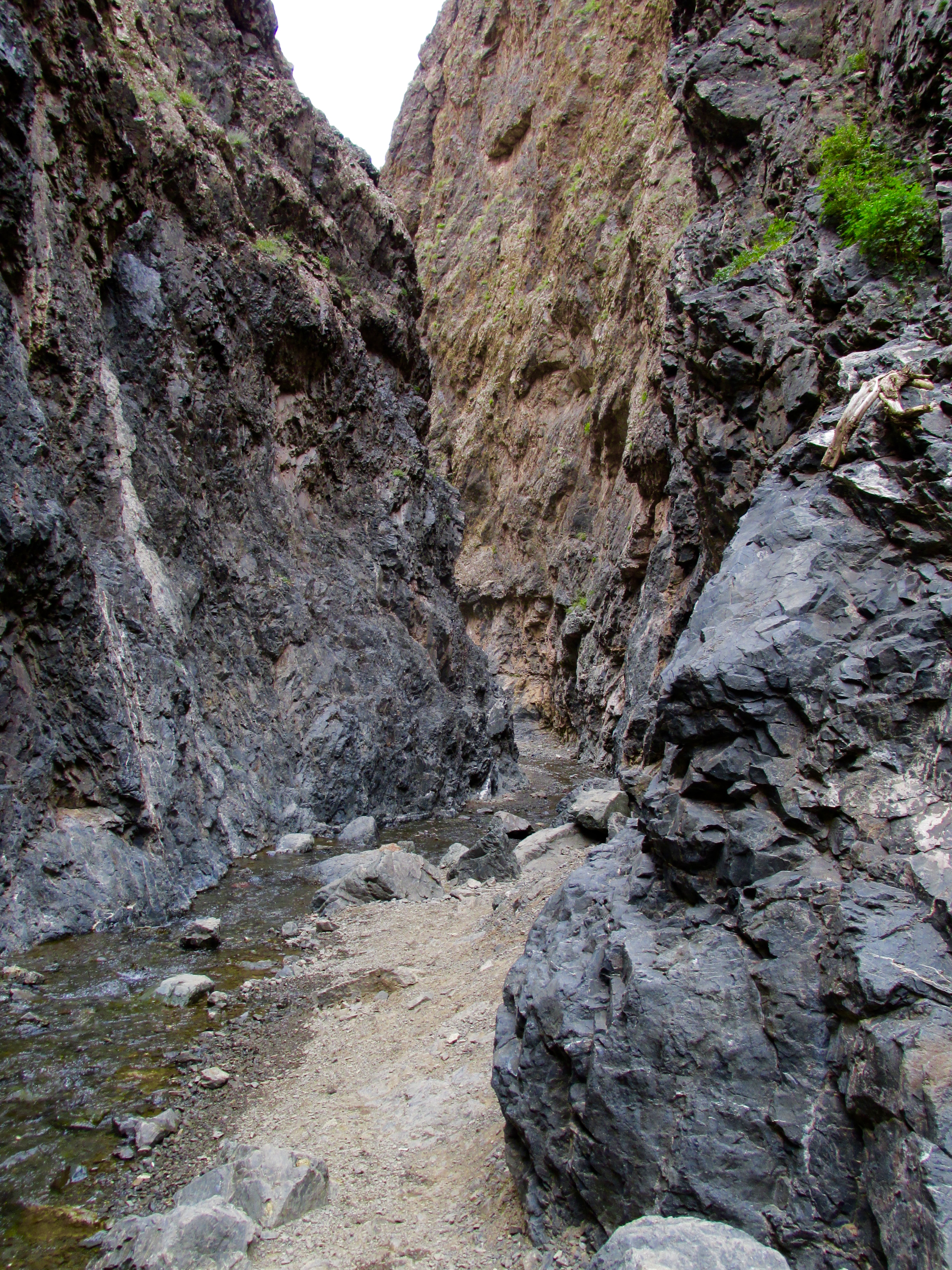


 The trails are wonderfully diverse; I start on a shaded path alongside a stream, emerge into some prairie-like flats, then climb on exposed red rock one morning.
 I return that afternoon to find even thicker clouds, but the peaks and the swoop are in slightly sharper relief. I snap away, hoping the wind will die down enough to allow the iconic reflection of the massif in the lake. It is not meant to be, and I leave the White River National Forest feeling better about the clarity of my new photos but still not very satisfied.
 Unlike my usual self, I decide I simply must have a better photo and set my alarm for 4:15 am to try to catch the sun rising on the face of the Bells. The next morning, four of us bundle up and head to the lake once more. Hopeful and shivering cold, we walk the shore of the lake, pacing up and down the beginnings of several trails, then set up with a few other hardy souls for the spectacle to come. The sky is clear and slowly turning orange behind us and pinkish blue in front.
 Ten minutes after official sunrise, the crests ignite! We are all clicking away as the rosy light gradually lights up the whole face. Suddenly … jubilation! The lake grows still and flat, and the fire on the mountain is mirrored in the water. It is this amateur photographer’s dream come true, and I snap away with both Nikon and iPhone until my batteries fail. (I did say amateur.)
 If you search for images of the Maroon Bells, you will find photos that blow your mind. Mine are no match for those, but I am happy with them, and happier still that I made the effort to capture to the best of my ability a place I may never get to see again. I was indeed
